That last sentence is the single most important thing on this page, because it is not what the address will be marketed as. This project sits on the belt that everyone calls Soukya Road, and Soukya Road is genuinely the corridor it belongs to — but the road itself is 1,146 metres away in a straight line and 4.45 kilometres away by road, and not one routed journey from this site to Whitefield, ITPB, KR Puram or Hope Farm uses it. This page publishes the routed geography as it actually is: the roads a resident would drive, the stations they could realistically reach, the schools and hospitals that exist within range, and the several things at this address that do not exist yet and are not funded to.
Every distance below is road distance, routed and cross-checked. None of it is straight-line, and none of it is a free-flow drive time. In Bengaluru the two diverge violently — Budigere Cross is 9.43 km from here as the crow flies and 18.35 km by road — and a location page built on straight lines is not a location page.
Macro Positioning — the Far Side of the Whitefield Belt
Bengaluru's eastern growth has run outward in visible rings. Whitefield's core — ITPB, EPIP, Hope Farm, Kadugodi — consolidated through the 2000s and 2010s and is now a mature, expensive, fully-served submarket. Beyond Kadugodi the character changes within a few kilometres: the built edge thins, the road network drops from arterial to two-lane, and land use shifts to a mix of agriculture, small industry and, increasingly, Grade-A warehousing. Hoskote taluk is where that transition happens.
Embassy Millennium sits inside that transition zone rather than beyond it. The critical numbers are these: Kadugodi Tree Park metro station is 7.12 km by road, Hope Farm Circle 7.99 km and ITPB Gate 1 8.22 km, while Hoskote town — the taluk headquarters the address is named for — is 14.47 km. The site is twice as close to Whitefield as it is to its own taluk town. Administratively it is Hoskote; functionally it is outer Whitefield, and every school run, hospital visit and mall trip described further down this page runs west, not east.
The wider belt has an economic identity of its own that buyers should understand rather than ignore. The Hoskote NH-75 logistics and warehousing corridor is 10.32 km away, KIADB Hoskote Industrial Area 18.61 km, and East Bengaluru absorbed 46 per cent of the city's H1 2026 warehouse leasing. This is not a leafy residential suburb that happens to have some godowns. It is a working industrial and agrarian belt into which a residential high-rise is being introduced.
The Address, Corrected — an NH-648 Frontage
| Measure | Value |
|---|---|
| Actual frontage road | NH-648, the Dabaspete–Hosur Highway — two lanes, 307 m from the pin |
| Perpendicular offset, pin to Soukya Road centreline | 1,146 m |
| Nearest point on Soukya Road, by road | 4.45 km — a 3.9× detour, because no local road connects north |
| Soukya Hospital Junction, where Soukya Road begins | 3.49 km, entirely along NH-648 |
| Nearest open Satellite Town Ring Road carriageway, by road | 13.18 km |
Two corrections matter here, and both cut against the way this corridor is usually sold.
This is not a Soukya Road frontage. The 4.45 km figure is not a rounding difference from the 1,146 m straight-line offset — it is a 3.9× detour, caused by the absence of any connecting road running north from the parcel to the Soukya Road alignment. Every westbound trip from this site instead runs NH-648 → Channasandra Main Road → Whitefield Road. Soukya Road is the corridor label, and a reasonable one; it is not the address.
This is not a Satellite Town Ring Road frontage either. The new STRR carriageway runs 5.60 km east of the site and is still under construction at this latitude. The nearest section actually open to traffic is 6.62 km away in a straight line and 13.18 km by road. Any page that sells this parcel on STRR adjacency is selling a road that is neither adjacent nor finished.
Three smaller geographic points are worth setting straight while we are here, because the corridor's marketing material gets them wrong routinely. Soukya Road runs east–west, not Whitefield-to-Hoskote — the Whitefield-to-Hoskote axis is SH-35, a separate road. The western arm running from Hope Farm to Soukya Hospital Junction is properly Channasandra Main Road. And Soukya Road does not reach Chikka Tirupathi; it feeds NH-648, which does — the great majority of the 14.53 km run from here to Chikka Tirupathi is NH-648. Finally, Kannamangala is not on Soukya Road: it lies 5.57 km from the centreline and 7.62 km from this pin.
We have also seen "10-lane NH-75" and "Soukya Road widening" claims attached to this corridor. Neither traces to a government source. Both appear only on competitor marketing pages, and neither is published here.
The Administrative Identity
| Field | Value |
|---|---|
| Revenue village | Bodanahosahalli (village code 625721) |
| Hobli | Anugondanahalli |
| Taluk | Hoskote |
| District | Bengaluru Rural |
| Postal code | 560067 |
| Coordinates | 12.981258, 77.806128 · Plus Code 7J4VXRJ4+GF2 |
| Survey numbers | Sy. Nos. 32/2, 32/3, 33/1, 33/2, 33/3, 34/1, 34/2, 34/3, 85/1, 85/2, 85/3, 83/1(P), 83/2(P) and 82/5 (old Sy. No. 82/3(P)) |
| Land tenure | Joint Development Agreement, status "Acquired" |
| Planning jurisdiction | A Local Planning Authority under BMRDA |
The developer's own environmental filing spells the village Bhodhanahosahalli in its plot description; the standard and searchable spelling, and the one used throughout this site, is Bodanahosahalli. The nearby bus stop is signed Bhodana Hosahalli. These are the same place.
On the district name. The Karnataka cabinet renamed Bengaluru Rural district to Bengaluru North on 2 July 2025. The district still exists — it was renamed, not dissolved — and the developer's own filing continues to use Bengaluru Rural, so that is the form used here. Expect to encounter both.
On the postal code, which needed correcting. OpenStreetMap returns 560117 for this pin. India Post has no record of that code at all. None of Bodanahosahalli, Doddadunnasandra, Anugondanahalli or Dunnasandra has its own post office, and the nearest delivery offices in the Hoskote block — Samethanahalli BO, Kalkunte BO, Naduvathi BO and Devanagundi BO — are all under 560067, which is also the code SOUKYA publishes for Samethanahalli on this same road. 560067 is what this site uses. Note two things: 562114 is Hoskote town and does not apply to this parcel, and the address the developer eventually markets may differ from the one derived here.
On planning jurisdiction. The parcel sits in a gram panchayat under a Local Planning Authority beneath the Bangalore Metropolitan Region Development Authority. BMRDA operates over roughly 10,000 sq km under the BMRDA Act 1985 and has nine Local Planning Authorities beneath it, including Hoskote LPA and the Satellite Town Ring Road Planning Authority. Which of those two covers Bodanahosahalli is not something we have been able to resolve — the STRRPA notified-village list was unreachable — so this site says "a Local Planning Authority under BMRDA" and names both possibilities rather than guessing.
Two consequences follow, and they matter more to a buyer than the acronym does. First, "BMRDA approved" is market shorthand, not the name of a sanctioning body. BMRDA sits above the LPAs; it does not sanction individual developments and it issues no khata at all. Second, the site is outside BBMP and outside the Greater Bengaluru Authority. The GBA, constituted on 15 May 2025 and operational from 2 September 2025, replaced BBMP inside the city area across roughly 712 sq km, splitting it into five corporations. Hoskote taluk is not in it. In practice that means a panchayat khata issued through e-Swathu Form 9 and Form 11, not a BBMP or GBA A-khata — a different documentation trail, a different service provider and a different resale conversation.
Road Connectivity
| Anchor | Routed km |
|---|---|
| NH-648 frontage | 0.31 |
| Soukya Hospital Junction | 3.49 |
| Anugondanahalli, the hobli headquarters | 4.50 |
| Hope Farm Circle | 7.99 |
| Chikka Tirupathi | 14.53 |
| Hoskote town | 14.47 |
| KR Puram | 16.27 |
| Budigere Cross | 18.35 |
| Kempegowda International Airport | 44.66 |
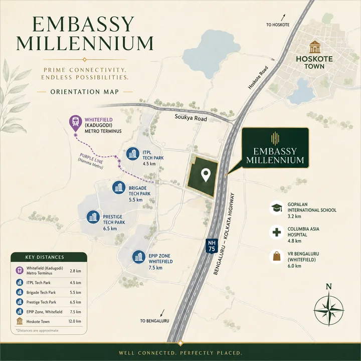
The connectivity story here is simple to state and important to grasp: there is one pipe. Every westbound journey — to work, to school, to hospital, to a mall, to the metro — leaves the site on NH-648, covers about 2.8 km on it, turns onto Channasandra Main Road for about 3.2 km, and joins Whitefield Road. Only the trip east to Hoskote town escapes that sequence. NH-648 at this point is a two-lane national highway, not a divided arterial. A same-developer shortlist can feel simpler than it really is; Embassy Biome keeps attention on how each Bengaluru address solves a different routine, budget, and documentation question.
That single-corridor dependence is the structural risk at this address, and no distance table shows it. A table of routed kilometres implies a network; what exists is a chain. An incident, a rain event or a construction closure anywhere on that 6 km chain affects every trip a household makes on that day. Buyers should drive the NH-648 → Channasandra → Whitefield Road sequence at 8:30 in the morning before deciding anything else about this project.
Budigere Cross is worth calling out separately because the corridor's marketing keeps using it as a nearby anchor. It is 9.43 km away in a straight line and 18.35 km by road — a 1.95× trap. It is not a nearby anchor.
Rail — the Railhead Nobody Mentions
| Station | Routed km |
|---|---|
| Devangonthi (DKN) | 4.55 |
| Whitefield (WFD) | 6.84 |
| Malur | 23.30 |
Devangonthi is the nearest railhead at 4.55 km, and it is the most under-discussed asset at this address. It runs roughly eleven local and MEMU services to Whitefield station, a distance of about 8 km covered in five to nine minutes. For a household with one commuter working in the Whitefield core, a drive-and-ride via Devangonthi is a genuine alternative to sitting in the NH-648 chain — and it is the one connectivity option here that does not depend on the single road pipe.
It is fair to be sober about it: eleven services is a commuter timetable, not a metro headway, and the last mile at the Whitefield end still has to be solved. But it exists, it is operational today, and it is closer than any metro station.
Hoskote has no passenger railway station. A sweep of the bounding box containing Hoskote town returns only Devangonthi, Whitefield and Malur.
Metro — Stated Plainly
| Station | Routed km | Note |
|---|---|---|
| Kadugodi Tree Park | 7.12 | nearest operational, roughly 26 minutes at peak |
| Hopefarm Channasandra | 7.33 | |
| Whitefield (Kadugodi) terminus | 8.38 | nearest in a straight line, farthest by road |
Three things about the metro at this address, in order of how often they are misrepresented.
First, the nearest station is 7.12 km away and the last mile is not walkable. Seven kilometres is roughly a ninety-minute walk. The honest framing is drive-and-park, an auto, or a feeder bus — not "metro connectivity".
Second, the ranking inverts. The Whitefield (Kadugodi) terminus is the closest station to this site in a straight line at 5.46 km, and the farthest by road at 8.38 km. Kadugodi Tree Park, one station short of the terminus, is the practical answer. This is exactly the kind of error a crow-flies distance table produces.
Third, and most important: there is no sanctioned metro extension toward Hoskote, Soukya Road or anywhere east of Kadugodi. Namma Metro Phase 3, approved by the Union Cabinet in August 2024 at ₹15,611 crore for 44.65 km and 31 stations, comprises two western corridors — the Orange Line from Kempapura to JP Nagar 4th Phase, and the Silver Line from Kadabagare to Hosahalli. Phase 3A is Hebbal to Sarjapur. The only funded work beyond Kadugodi is a 588-metre reversal and stabling spur with no new stations, tendered in 2023 at ₹42.30 crore. A KR Puram–Hoskote line of roughly 16 km exists as a feasibility idea; it is not sanctioned, it has no allocation, and it would run along NH-75 through Budigere Cross — a different corridor, 14 to 18 km from here. Nearly all of the detail circulating about it comes from competitor builder microsites rather than from BMRCL.
If a metro extension is part of your investment thesis for this address, it should be held as an option with no date and no funding, not as a pipeline item.
Buses and the Last Mile
There is a bus stop named Bhodana Hosahalli 0.47 km from the pin, with Dunnasandra at 1.23 km and Samethanahalli at 1.73 km. BMTC routes 304Q, 305, 305P, 306, 306MA and 322 are reported to serve the Soukya Road corridor. Which of them actually reach the site's own stop, and at what frequency, is not something we have been able to verify — so this page says "reported", not "served by". A prospective buyer who intends to rely on public transport should confirm the timetable at the stop itself.
The Airports
Kempegowda International Airport is 44.66 km by road. That is the commercial airport for this address, and at that distance it is a planned journey rather than a casual one.
HAL Airport is much closer at 15.34 km, and it matters here for a reason that has nothing to do with flying. Because the site falls inside HAL's 20 km radius, building height at this parcel is governed by a No Objection Certificate from Hindustan Aeronautics Limited's own committee under the Aircraft Act 1934 and the 2015 height rules — not by Kempegowda, which at 26.40 km is outside the regulated radius. Any height argument at this address that invokes Kempegowda is looking at the wrong aerodrome. The mechanics of that ceiling, and how the filed building envelope sits inside it, are set out on the master plan page.
Employment
| Employer / node | Routed km |
|---|---|
| ITPB / ITPL Gate 1 | 8.22 |
| EPIP Zone | 10.27 |
| Hoskote NH-75 logistics and warehousing belt | 10.32 |
| Prestige Shantiniketan | 10.35 |
| Brigade Tech Gardens, Brookefield | 14.40 |
| Embassy Tech Village, Outer Ring Road | 18.51 |
| KIADB Hoskote Industrial Area | 18.61 |
| Malur industrial belt | 23.66 |
| Manyata Embassy Business Park | 26.31 |
| Narasapura Industrial Area, Kolar | 41.72 |
The employment position is better than the taluk name suggests and worse than the raw kilometres suggest. ITPB at 8.22 km and EPIP at 10.27 km put the two largest employment clusters in East Bengaluru within a short routed distance — but every one of those trips runs through the single NH-648 → Channasandra → Whitefield Road chain, and Whitefield Road at peak is among the most congested arterials in the city. The Outer Ring Road nodes at 18.51 km and Manyata at 26.31 km are cross-city commutes that this address does not shorten.
For a household with an ITPB, EPIP or Brookefield workplace, this is a viable commute. For one with an ORR or North Bengaluru workplace, it is not, and no amount of corridor narrative changes that.
Schools
| School | Routed km |
|---|---|
| Bangalore International Academy, on Soukya Road | 3.55 |
| Greenwood High Pre-school, Whitefield | 8.73 |
| Vydehi School of Excellence | 10.76 |
| Chrysalis High, Bengaluru East | 10.90 |
| Glentree Academy | 10.99 |
| Gopalan International School | 12.26 |
| VIBGYOR High, Kadugodi / Budigere | 14.10 |
| Deens Academy, Gunjur | 15.72 |
| Greenwood High International, Sarjapur | 17.52 |
There is exactly one named school within four kilometres. After Bangalore International Academy at 3.55 km, the next name on the list is 8.73 km away, and the recognised private schools that families relocating here would typically shortlist begin at Whitefield and run to Sarjapur.
The straight-line-to-routed gap is severe on this list and worth spelling out, because school-distance claims on competitor pages are frequently crow-flies figures. Chrysalis High is 6.53 km away in a straight line and 10.90 km by road. VIBGYOR High is 8.72 km straight and 14.10 by road. Deens Academy is 8.91 km straight and 15.72 by road. The multiplier is roughly 1.7× throughout — which means a school bus route, in morning traffic, on a two-lane highway.
Hospitals
| Hospital | Routed km |
|---|---|
| Ayurvedagram Heritage Wellness Centre | 1.77 |
| SOUKYA International Holistic Health Centre | 3.58 |
| Motherhood Whitefield | 9.32 |
| Cloudnine Whitefield | 9.84 |
| Manipal Hospital Whitefield | 10.19 |
| Vydehi Institute of Medical Sciences | 10.57 |
| Hoskote Government Hospital | 15.22 |
| Sakra World Hospital, Outer Ring Road | 18.51 |
The two closest facilities are wellness centres, not hospitals. Ayurvedagram at 1.77 km and SOUKYA at 3.58 km are both well-regarded holistic and Ayurvedic institutions, and SOUKYA is the landmark the whole corridor is named after — but neither is where you go with a fracture or a cardiac event.
The nearest general hospital is Motherhood Whitefield at 9.32 km, with Manipal Whitefield — the multi-specialty anchor for the belt — at 10.19 km and Vydehi at 10.57 km. Note that Manipal acquired Columbia Asia India in 2021: Columbia Asia Whitefield and Manipal Hospital Whitefield are the same building, and any page listing them as two separate nearby hospitals is double-counting. In an emergency, at peak hour, on this road, plan for the 10 km rather than the 1.77 km.
Retail
| Destination | Routed km |
|---|---|
| Nexus Whitefield, formerly Inorbit | 9.17 |
| Nexus Shantiniketan, formerly Forum Shantiniketan | 10.57 |
| Hoskote town retail | 14.47 |
| VR Bengaluru | 14.55 |
| Phoenix Marketcity, Mahadevapura | 14.85 |
No organised mall within nine kilometres. The Whitefield mall cluster — Nexus Whitefield and Nexus Shantiniketan — sits at 9.17 and 10.57 km, and the larger Phoenix Marketcity and VR Bengaluru formats are 14 to 15 km away. Both Whitefield malls changed hands and were rebranded under the Nexus platform; listings still calling them Inorbit and Forum are out of date.
Day-to-day convenience retail near the site is the village-format kind: local kirana, a handful of roadside establishments on NH-648, and the Hoskote town market 14.47 km east. A large-format grocery run is a Whitefield trip.
What Is Actually Around the Site Today
It is worth being concrete about the immediate setting rather than describing it as "emerging". Within about 3.5 km of the pin, the mapped landmarks are a biscuit factory, a state warehousing godown, an Ayurvedic hospital and a set of village bus stops. That is the neighbourhood as it exists in 2026.
The wider belt is one of India's larger Grade-A warehousing hubs, and it is growing — East Bengaluru took 46 per cent of the city's H1 2026 warehouse leasing. For an investor that industrial depth is a demand argument, because warehousing and light industry generate mid-income rental demand that apartment stock in this belt can serve. For an end-user expecting a settled residential neighbourhood at handover, it is a different picture entirely, and the honest expectation is that the residential character of this pocket will be created largely by projects like this one rather than found already in place.
Water, Power and Services
The parcel is outside BWSSB's Cauvery network. Until that changes it is a borewell and tanker location, with treated water recycling doing whatever work the eventual scheme design gives it.
Cauvery Stage VI — a ₹6,939 crore scheme adding 500 MLD and covering Hoskote, Devanahalli and Anekal — was approved by the Karnataka cabinet in February 2026. It is at planning stage. The earliest supply date discussed publicly is around 2028, and whether the approved scope reaches Anugondanahalli hobli or stops at Hoskote town is not established. Treat piped Cauvery water at this address as a possibility later in the ownership horizon, not as an amenity at handover.
The Honest Trade-offs
The address will be marketed as something it is not
Soukya Road is 4.45 km by road. The frontage is a two-lane national highway. Neither the Satellite Town Ring Road nor any widened arterial runs past this parcel today.
One commute pipe
NH-648 → Channasandra Main Road → Whitefield Road carries essentially every trip this household will make. Test it at peak before committing.
The social infrastructure is 9 to 10 km away
No organised mall within 9 km, no recognised private school within 8 km beyond a single name at 3.55 km, and no general hospital within 9 km. Life at handover depends on Whitefield.
The surroundings are industrial and agrarian
A biscuit factory, a warehousing godown and village bus stops are the current landmarks. The warehousing belt is expanding, not contracting.
Panchayat khata, not A-khata
An e-Swathu Form 9 / Form 11 khata outside BBMP and outside the Greater Bengaluru Authority. Different documentation, different services, and a different conversation at resale.
No Cauvery water, and no sanctioned metro east of Kadugodi
Both are live possibilities with no delivery date. Neither should be priced in.
Nothing here can be sold yet
Embassy Millennium is not registered with Karnataka RERA, and no application for it has been filed. A full parse of the K-RERA project registry returns fourteen Embassy-promoted registrations across Karnataka — Greenshore, Verde, Verde Phase 2, Paradiso, Springs Phase 1 and 2A, Lake Terraces, Grove, Boulevard, Embassy One, Eden, East Avenue and Serene Amara — and not one of them is in Hoskote taluk, and none is named Millennium. That is consistent with the project's stage rather than surprising: it holds environmental Terms of Reference granted in April 2026 and its Environmental Clearance application is still under verification, and developers ordinarily register with RERA at or shortly before launch. Under Section 3 of the Real Estate (Regulation and Development) Act 2016 no development of this scale may be marketed, reserved or transacted before it is registered, so no booking money can be accepted and no allotment or sale document executed before then. Verify at rera.karnataka.gov.in.
The Investment Case for This Micro-Market
Set out plainly, and without the corridor's usual embellishments, the case for this micro-market rests on four things.
Price position relative to Whitefield. Two Grade-A comparables within roughly eight kilometres anchor the local rate: Godrej Parkshire at Sarakariguttahalli, a January 2026 launch of 1,132 units on 14 acres, at ₹11,100 per sq ft; and Provident Botanico on Soukya Road, 1,275 units on 17.12 acres, under construction, at ₹11,339 per sq ft. Both figures were cross-checked against per-unit price and size tables rather than taken from headline rates. That is a meaningful discount to the mature Whitefield core, and it is the corridor's primary argument.
A functioning employment base already within routed range. ITPB at 8.22 km and EPIP at 10.27 km are not speculative. The rental demand they generate exists today.
A rail option that is genuinely close. Devangonthi at 4.55 km, with roughly eleven services covering the 8 km to Whitefield station in five to nine minutes, is the only connectivity asset at this address that bypasses the single road pipe.
Local economic activity from the build itself. The developer's environmental filing discloses 335 permanent construction posts across 575,640 man-days over 1,560 days, and 563 permanent operational posts once complete. That is a real, filed number rather than a marketing one.
Against those, two counterweights belong in the same paragraph rather than a footnote. Bengaluru carried 72,800 unsold units at Q1 2026, up 24 per cent year on year, at a fourteen-month overhang, with East Bengaluru holding half of it. A buyer entering this corridor is entering the most heavily supplied submarket in the city. And the local transaction record is too thin to price from: Hoskote's government-registered transaction average is ₹5,300 per sq ft, and the registration sample in this hobli runs to two registered sales between September 2025 and August 2026. That average is a floor for stamp duty purposes, not a comparable.
The reasonable conclusion is that this micro-market is an early-cycle position with a real employment anchor, a real rail option and a real price gap to Whitefield — and with infrastructure, retail and healthcare depth that will have to be delivered over the ownership horizon rather than found on arrival. That is a defensible investment case. It is not a low-risk one, and anyone presenting it as such is not reading the same routed distances.
Plan a drive to the site
We can send the exact pin, the approach route and the honest drive times measured on the road rather than in a straight line.
Talk to a Sales ConsultantFrequently Asked Questions
Embassy Millennium Location FAQs - Frequently Asked Questions
Not as a frontage. Soukya Road is 1,146 metres away in a straight line but 4.45 kilometres by road, because no local road connects north from the site. Soukya Hospital Junction, where the road begins, is 3.49 km away entirely along NH-648, and no routed trip from this pin to Whitefield, ITPB, KR Puram or Hope Farm uses it at all. It is a fair label for the corridor; it is not the address, and this site does not present it as one.
Administratively Hoskote taluk; functionally a Whitefield-side address. Kadugodi Tree Park metro is 7.12 km by road, Hope Farm Circle 7.99 km and ITPB Gate 1 8.22 km, while Hoskote town is 14.47 km away. The schools, hospitals, malls and offices a resident would use are all in the Whitefield belt. The pin is twice as close to Whitefield as to the taluk it is named for.
Kadugodi Tree Park on the Purple Line, at 7.12 kilometres by road — roughly 26 minutes at peak. Hopefarm Channasandra is 7.33 km and the Whitefield (Kadugodi) terminus 8.38 km; that last is worth noting because the ranking inverts, the terminus being closest in a straight line at 5.46 km and farthest by road. None is walkable — 7.12 km is a ninety-minute walk — so the realistic last mile is a feeder bus or a private vehicle.
There is no sanctioned metro toward Hoskote, Soukya Road or anywhere beyond Kadugodi. Phase 3, approved by the Union Cabinet in August 2024 at ₹15,611 crore for 44.65 km and 31 stations, funds two western corridors, and Phase 3A runs Hebbal to Sarjapur. The only funded work east of Kadugodi is a 588-metre reversal and stabling spur with no new stations. A KR Puram–Hoskote line of roughly 16 km is a feasibility idea, unsanctioned, on a corridor 14 to 18 km from here.
All road distances, not straight-line: ITPB / ITPL Gate 1 8.22 km, Hope Farm Circle 7.99 km, EPIP Zone 10.27 km, Prestige Shantiniketan 10.35 km, Brigade Tech Gardens 14.40 km, KR Puram 16.27 km, Embassy Tech Village 18.51 km, Manyata Embassy Business Park 26.31 km and Kempegowda International Airport 44.66 km. The caveat matters more than any single number: every westbound journey funnels through the same sequence — NH-648, Channasandra Main Road, Whitefield Road — so these distances share one point of failure.
Yes, and it is the connectivity asset most marketing for this belt leaves out. Devangonthi railway station is 4.55 kilometres away by road, with around eleven local and MEMU services to Whitefield — an eight-kilometre hop taking five to nine minutes. Whitefield railway station is 6.84 km and Malur 23.30 km. Hoskote itself has no passenger railway station; a sweep of its bounding box returns only Devangonthi, Whitefield and Malur.